HL Paper 2
(i) Define the term littoral drift (longshore drift).
(ii) Briefly describe one named feature caused by littoral drift.
Explain the formation of two ocean floor landforms associated with volcanic or tectonic activity.
“The loss of coral reefs is not just a local concern.” Discuss this statement.
Markscheme
(i) The transport/movement of sediment along a coast [1 mark] by wave action/swash and backwash [1 mark]. Credit alternative phrasing.
(ii) Accept spits, bars, tombolos, cuspate forelands, beach cusps, drift-aligned beaches as the named feature. There should be a brief description of the chosen landform eg, a spit [1 mark] is a ridge of shingle that is attached to the mainland at one end [1 mark].
Features include underwater volcanoes, black smokers, trenches, transform faults, mid-ocean ridges and rifts, seamounts, guyots. The explanation should refer to either processes at divergent boundaries (upwelling magma and sea floor spreading) and/or
processes at subduction zones.
In each case, award up to [2 marks] for identification and description of the land forms and up to [2 marks] for explanation of its formation (maximum [3 marks]).
For example, an ocean trench [1 mark] is a very deep area of water parallel to the coast [1 mark] where one plate subducts under another [1 mark].
Economic and environmental issues can be investigated at both the local and other scales, for instance coral reefs have global biological importance in terms of high biodiversity, potential for medicine, while locally coral reefs also protect coasts by absorbing the strength of hurricanes and tropical storms. Economically they are important breeding grounds for fish and support local incomes, while globally coral reefs can be used to stimulate international tourism in visiting coral reefs. A local issue could include income generated from activities on coral reefs or that use coral eg, souvenirs, jewelry etc.
To achieve band D, responses will describe a few concerns probably at one scale only.
At band E, expect either a more detailed range of issues (concerns) such as economical/social/environmental, local and global, positive and negative or some explicit discussion of the statement (might contrast local/economic concern with global/environmental concern).
At band F, expect both.
Marks should be allocated according to the markbands.
Examiners report
The definition of littoral drift was generally well understood. Many candidates were able to identify a feature caused by littoral drift, such as spit or tombolo, but often did not describe the feature, choosing instead to explain its formation.
There was sound knowledge of the landforms associated with volcanic or tectonic activity, but the explanation of their formation was often not developed.
There were some very strong answers about coral reefs and generally no overall problems with interpreting this question. A lot of attention was given to the ecological impacts. Many answers tended to be rather descriptive, or tended to focus on local rather than global issues, with limited discussion of the statement.
The diagram shows a model of coastal advance and retreat.
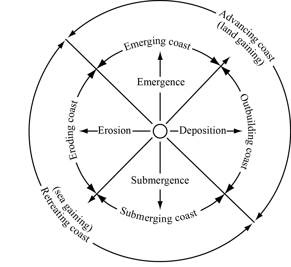
[Source: http://science.jrank.org/article_images/science.jrank.org/coasts-and-coastal-processes.1.jpg]
Identify two reasons shown on the diagram why some coasts advance.
Explain why cliffs are often found along retreating coasts.
Explain the global distribution of ocean ridges.
Examine how the exploitation of one named oceanic resource has led to geopolitical conflict.
Markscheme
Emergence / an emerging coast [1 mark].
Deposition / an outbuilding coast [1 mark].
Sea is gaining/eroding the land to cause a cliff [1 mark]. Award further marks for an explanation of two or more processes, or an explanation of the cyclical nature of cliff erosion (wave-cut notch and subsequent collapse). Another approach may be to argue that a sea-level rise exposes new parts of the coastline to erosion/undercutting. There may be alternative explanations.
Ridges are a linear belt of submarine mountains / or other definitional statement [1 mark]. They occur at spreading (divergent) plate boundaries [1 mark] where convection currents in the mantle cause the plates to diverge thus allowing magma to rise [1 mark]. The mid-ocean position should be clear [1 mark] and additional marks should be awarded for use of examples.
Other valid developments (including those using a diagram) can be awarded marks in substitution for those identified above.
The question does not specify a particular resource, so candidates may examine fish, oil or other mineral resources. There should be some identification of the countries involved, the resource, the dispute and the nature of the conflict.
To reach band E and above, candidates are expected to have used one or more detailed, named examples. Potential examples include: Canada, Denmark, Norway, Russia and USA over Arctic oil and gas; South Korea and Japan over the East Sea/Sea of Japan (either oil or fishing).
Marks should be allocated according to the markbands.
Examiners report
Some responses explained the cycle of cliff formation well – focusing on wave action, undercutting and falling away of sections of the coastline.
This question was either understood and done well or completely misunderstood. Some recognized the location mid-ocean and on the plate margins but most were unable to locate ocean ridges and many thought they were on the edge of continents.
“Geopolitical” was not understood by many. A description was given on the perils of overfishing, for example. Those who made specific reference to a named resource, for example, oil or fish, were able to place it in context to a conflict, with some clear identifications of the problem and why/how the conflict is occurring.
The map shows surface ocean currents in the Atlantic Ocean in January.
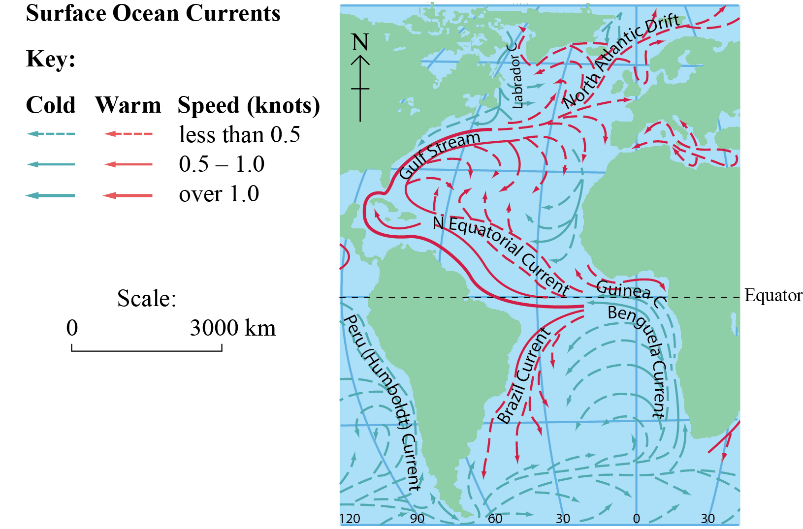
cartography ©Philips
Describe the pattern of ocean currents shown on the map.
Explain the functioning and importance of the oceanic conveyor belt.
“Ocean fishing can never be sustainable.” Discuss this statement.
Markscheme
Warm ocean currents move water away from the equator whereas cold ocean currents move water away from cold regions towards the equator. Warm currents tend to be on the west side of the Atlantic ocean and cold currents tend to be on the east. The current circulation in the northern hemisphere is clockwise; in the southern hemisphere it is anticlockwise. The northern Atlantic does not have a circumpolar current, whereas the southern Atlantic does. Warmer currents appear to be faster than colder currents. Anomalies such as the Labrador current should be credited.
Award 1 mark for each valid point made up to a maximum of 4 marks. Award a maximum of 2 marks for a listing/description of currents where no pattern is identified or described.
Functioning (how it works) – the oceanic conveyor belt is important for the transfer of energy. In polar regions, cold, salty water sinks into the depths and makes its way towards the equator. This cold, dense water sweeps around Antarctica and then spreads into the deep basins of the Atlantic, the Pacific and the Indian Oceans. Surface currents bring warm water to the North Atlantic from the Indian and Pacific Oceans.
Importance (why it matters) – it raises temperatures in some mid-latitudes such as the British Isles and Scandinavia. It also influences the amount of rainfall received in certain areas. In addition, it brings nutrients up from the seabed and carries them around the world creating valuable fishing grounds. This benefits a range of human activities including agriculture, tourism and ocean navigation.
Award a maximum of 4 marks if only functioning or importance is explained.
Sustainability needs to be explained in terms of maintaining fish catches (or yields) without causing any decline in stocks.
Sustainability measures include quotas, bans and the closing of fishing areas. However, these still fail to address the real problems of the fishing industry: too many fishermen are chasing too few fish and too many immature fish are being caught. For fisheries to be protected and for the industry to be competitive on a world scale, the number of boats and the number of people employed in fishing must be reduced. At the same time, the efficiencies which come from improved technology could be considered. The industry’s fishing capacity continues to increase. The number of vessels is increasing slowly. However, each boat has greater capacity due to improved technology. Due to overcapacity, much of the investment in new technology is wasted. The amount of fish caught at sea has barely changed in the last decade. Fish stocks are depleted, so the effort to catch the fish remaining is higher than it needs to be.
Other themes that could be explored may focus on issues of increasing global consumption due to growing population numbers and affluence and long-term difficulties in matching rising demand with supplies, as well as the greater use of aquaculture.
Changes in dietary pattern could also have an influence, for example, the current trend in many MEDCs for moving from a red meat to a fish diet and fish supplements, increasing numbers of sushi restaurants etc.
Attempts to make fishing more sustainable – regulations: net sizes, line lengths, depth of fishing, education policies, establishment of non-fishing zones.
Valid alternative approaches should also be credited.
Answers accessing markbands E/F should include a balanced conclusion, however, they may be speculative.
Marks should be allocated according to the markbands.
Examiners report
Knowledge and understanding was limited, with the term "pattern of ocean currents" ignored by some candidates.
The importance of the oceanic conveyor belt was handled much better by candidates than was its functioning. Some candidates did not have any clear idea of what the oceanic conveyor belt is.
Descriptive case studies tended to overwhelm genuine discussion, with surprisingly few candidates offering evidenced accounts of sustainable fishing methods.
The graph shows the percentage of coral reefs that have been lost since 1960.

[Source: adapted from http://commons.wikimedia.org/wiki/File:World_Blank_Map_(Mercator_projection).svg]
Describe the pattern of loss of coral reefs.
State two physical factors which are needed for the development of coral reefs.
Explain three benefits that coral reefs bring to people.
Examine the conflicts which arise from competing land uses in coastal margins.
Markscheme
The greatest loss is in the Indian ocean and the least is in the Pacific [1 mark]. There is more loss in Eastern hemisphere than Western hemisphere [1 mark].
For a simple list with quantification award only 1 mark.
Award 1 mark each, for two of the following:
- availability of sunlight
- warm salt water
- clear, shallow water
- the accumulation of skeletal material, broken and piled up by wave action
- availability of calcium
- wave action providing oxygen and/or nutrients.
Other valid factors may be accepted.
The benefits may include: building materials, tourism, absorption of CO2, natural coastal protection, maintenance of biodiversity and fish stocks, and the biological links to mangroves.
Award 2 marks for each relevant explanation – 1 mark for identification of a valid benefit, and 1 mark for explanation/elaboration/exemplification.
Competing land uses which may lead to conflicts include the following: agriculture, tourist developments, fishing villages, coastal erosion mitigation projects, ports, industry, urban settlements, protected areas, aquaculture.
The conflict may also be between different places (for example, longshore drift interrupted by groyne/breakwaters leading to erosion elsewhere), or may change over time (for example, measures to protect an actively eroding cliff are abandoned as they are too costly to maintain).
Answers should examine land uses which are in conflict with each other, and while examples are not a specific requirement of the question, those answers that provide supporting examples are likely to access higher markbands.
To access bands E and F, expect at least two conflicts, one of which is well explained.
Marks should be allocated according to the markbands.
Examiners report
This was generally well done although a minority of candidates made a list rather than described a pattern.
This was generally very well done – candidates were clearly aware of the factors that are needed for the development of coral reefs.
Again, a well-developed answer, in general, with benefits being explained.
This question generated a variety of responses, from those that were focused and well supported to those that were not answering the question. The latter frequently meandered into geopolitics and competition for ocean resources rather than competing land uses along coastal margins.
The map shows the age of oceanic crust.

[Source: Computerized digital images and associated databases from the National Geophysical Data Centre, National Oceanic and Atmospheric Administration, U.S. Department of Commerce]
Referring to the map, identify the type of plate boundary shown on the map at:
(i) A
(ii) B.
State the age of the oceanic crust at C shown on the map.
Using an annotated diagram only, explain why the age of oceanic crust changes with distance from the mid-ocean ridges.
Referring to specific nations, discuss the geopolitical issues that arise over ocean areas.
Markscheme
The boundary type at A is constructive or divergent [1 mark] and at B is destructive or convergent (accept subduction but do not accept collision zone) [1 mark].
The age of the crust at C is between 141.9 and 156.8 [1 mark] million years BP [1 mark]. Any number within the range is acceptable; only answers within this range can gain the second mark.
Candidates must use an annotated diagram to answer this question. No credit should be given for any information that is written separately below the map unless it is clearly related to it by means of arrows or a key. As a general rule 3 marks should be awarded for the quality and appropriateness of the diagram and 3 marks for the quality of the annotations. This balance can be adjusted if exceptional quality is found in either of these two parts.
In good answers the annotations should include new crust being created at constructive plate boundaries which moves away from the boundaries as part of the process of sea-floor spreading. With distance the age of crust increases as a result of this divergent process.
As populations and resource demand increase, and standards of living increase, more pressure is placed on peripheries and boundary zones and the ownership of them. There are many areas of the world where issues arise as a result of oceanic territorial disputes. These issues may be a product of sovereignty rights, resource need, military advantage, historical situation or any other valid reason.
In some cases this may disadvantage nations who are not allied to a particular group or are members of an economic agreement and this may serve to impoverish nations or create tension.
Responses that are discursive are likely to be credited at bands E/F.
Marks should be allocated according to the markbands.
Examiners report
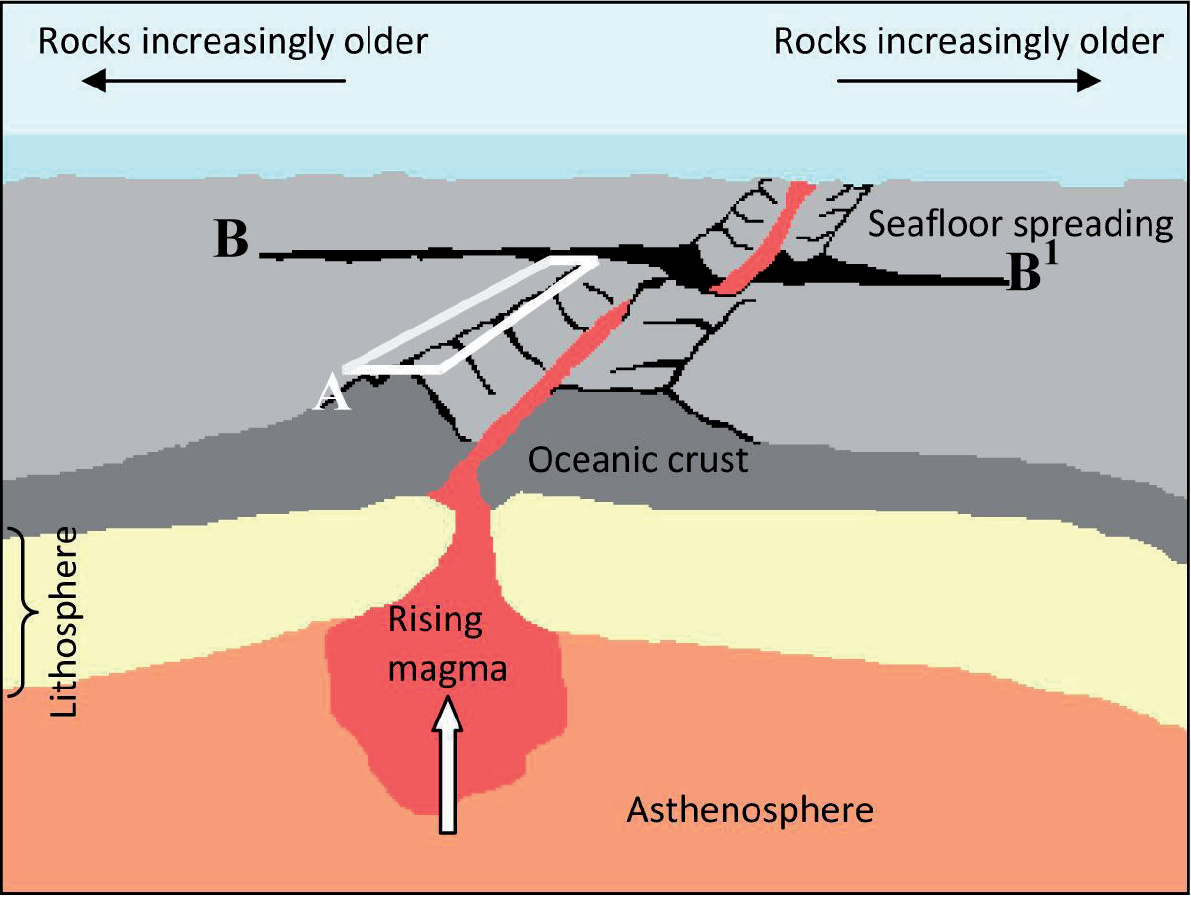
The diagram shows some of the main features of the ocean floor.
©International Baccalaureate 2013
Referring to the diagram, identify feature A and feature B–B1.
Explain why the ocean floor becomes increasingly older with distance from A.
Using an annotated diagram only, explain the formation of an ocean trench.
Examine why oceans are areas of geopolitical conflict.
Markscheme
A: Rift valley or ridge system or ocean ridge. Diverging or constructive plate boundary is also acceptable.
B–B1: Transform or transcurrent faults. Slipping fault/tear fault or a fault may also be acceptable.
As a result of sea floor spreading and the creation of newly “constructed” ocean floor at the constructive boundary [1 mark], the age of the floor increases with distance and the oldest floor is found, therefore, furthest away from the ridge and rift systems [1 mark].
The features of the trench should be clearly illustrated and explained on a diagram. The diagram should include:
- a trench where two plates are converging [1 mark]
- direction of plate movement [1 mark]
- the concept of subduction [1 mark].
Further 3 marks for explanatory annotations that identify:
- plate density
- convection cell
- sedimentation
- earthquakes along the Benioff zone
- or labeling that shows relevant located examples.
Award a maximum of 4 marks for a labeled diagram with an explanation which is separate from the diagram.
Award a maximum of 2 marks for an explanation without a diagram.
Likely sources of geopolitical conflict include: disputed islands, extended fishing zones, oil exploration, the possibility of gas extraction in the Arctic or hydrogen reserves in the Atlantic, use of Arctic and Antarctic areas.
As technology advances and exploration techniques improve, the potential of oceans as a source of biotic and abiotic resources has been realized. The need for these resources has resulted in nations extending, or wanting to extend, their boundaries, laying claim to substantial portions of continental shelves or areas which are now accessible due to ice melt. This may lead to altercations between nations who lay claim to the same areas of ocean floor or islands.
The emphasis must be placed on conflict and this may be the potential for armed conflict or political dialogue/negotiation.
Answers which examine a conflict in detail are likely to be credited at bands E and F.
Marks should be allocated according to the markbands.
Examiners report
The mid ocean ridge/rift valley system (A) was almost universally identified whereas the transform fault (B–B1) was almost universally not identified, in fact very few candidates recognized it as a fault, which would have been credited.
Most candidates provided a good explanation of why the ocean floor gets older with distance from the central ridge.
In general, candidates provided good diagrams of the formation of ocean trenches although many candidates provided descriptive labels rather than explanatory annotations.
Generally, this was answered well, with support mainly coming from the Arctic and its geopolitical conflict, though at standard level there was little reference to other important ocean areas of conflict, giving the responses too narrow a focus to reach the higher mark range.
Briefly outline the role of oceans as a source of carbon dioxide.
Briefly outline the role of oceans as a store of carbon dioxide.
Explain what is meant by the term “oceanic conveyor belt”.
Suggest two reasons why the oceanic conveyor belt is important.
Evaluate the success of one named conservation policy for sustainable fishing.
Markscheme
Award [1] for each of the following, up to a maximum of [2]:
- oceans are a source of carbon dioxide, which can be transferred to the atmosphere
- carbon dioxide is released during submarine volcanic activity
- carbon dioxide can be brought up from the ocean depths
- respiration of marine organisms
- other valid points.
Do not allow fossil fuels as a source.
Award [1] for each of the following, up to a maximum of [2]:
- the ocean is the major/largest store/sink of CO2
- acts as a sink for some of the carbon dioxide that has passed through the food chain; stored in sediments
- credit other valid points about oceanic storage of carbon.
Do not allow fossil fuels as a store.
Award [1] for each of the following, up to a maximum of [2]
- the oceanic conveyor belt (OCB), refers to part of the large-scale ocean circulation
- places/oceans/currents are linked by the OCB
- cause or a pattern of the OCB, eg density gradients or the process of wind driven surface currents.
Candidates may approach this question from the perspective of human importance and/or system importance.
In each case, award [1] for identifying a valid reason and a further [1] for development or exemplification.
Possibilities include:
- Moderation of climates [1], so the thermal growing season for agriculture is extended/tourist development [1].
- Important because it transfers global heat energy between latitudes [1]; if the circulation stopped it would cause significant climate change [1].
- The conveyer belt reduces temperature differences between oceans [1], therefore linking the oceans as a single global system [1].
- OCB brings nutrients to the surface [1], and this supports abundant marine life/fish [1].
Conservation policies, eg the EU’s Common Fisheries Policy (CFP), may refer to the total allowable catch, the harvesting of juvenile fish, limiting the number of vessels, checking of landings, limited access to fishing grounds.
Sustainable fishing is the maximum number/weight/amount of fish that can be caught in any one year without depleting the stock/population. A sustainable fishing policy allows a depleted stock to recover its size.
Good answers may evaluate critically what is meant by “successful” and the temporal and spatial scales this brings into consideration. Another approach might be to evaluate whether sustainable fish yields can cater for rising demand and changes in the distribution of fish.
At band D, expect some description of an identified conservation policy in relation to sustainable fishing.
At band E, expect either greater explanation of how an identified conservation policy tries to achieve sustainable fishing or a critical evaluation of the success of the policy.
At band F, expect both.
Examiners report
Define the term exclusive economic zone.
Briefly describe what is meant by continental shelf.
Explain the environmental and economic value of mangrove swamps.
Discuss the conflicts that occur from attempts to manage coastal hazards.
Markscheme
The exclusive economic zone is the area in which a sovereign state has rights [1 mark]. Award the second [1 mark] for either of the following concepts (words need not be exact):
- “over the economic resources of the sea, seabed and subsoil”
- “extending up to 200 nautical miles from the coast”.
The continental shelf is the gently sloping extension of most continental areas [1 mark] beneath the shallow ocean waters. Award an additional [1 mark] for any development of this idea such as “the width of the shelf is highly variable (from 0–1500 km)” or “the water depth over the shelf never exceeds about 200 m”.
Note that full credit should also be given if a candidate describes the alternative meaning of continental shelf, as used in the UN Convention on the Law of the Sea, which states that it is the stretch of the seabed (regardless of depth) [1 mark] adjacent to the shores of a particular country to which it belongs [1 mark].
Environmental values include coastal stabilization/protection, the conservation of biodiversity, a breeding ground for species, a refuge for many species, mitigation of storms (including tropical storms). They also act as natural filters, absorbing nutrients from farming and sewage disposal.
Mangroves have much economic value, such as providing large quantities of food, fuel, building materials and medicine. “Value” can be for local people (protection, fuel) or other groups/people, for example, TNCs, tourist industry.
Award [1 mark] for each value/benefit that is explained, and further marks for developed explanation, or applied use of examples, up to the maximum of [3 marks] for environmental and [3 marks] for economic value. For example, award [2 marks] for a statement such as: “One ha of mangrove in the Philippines can yield 400 kg of fish and 75 kg of shrimp”.
Coastal hazards include: tsunamis, storm surges, coastal retreat, coastal erosion and cliff failure.
Conflicts may occur between different land-uses, for example, tourism providers and environmental protection agencies (EPAs) (for example over the construction of coastal defences that spoil the aesthetics); land-use disputes/land zoning/managed retreat policies can conflict with plans of developers; local residents may object to development if they perceive that it will adversely affect property values; the allocation of funding (different organizations/users may be competing for limited funding). There may be conflict between environmentalists and EPAs as some hard engineering structures might interfere with sediment movement. Conflicts in LEDCs might focus on the need to maintain mangroves as coastal protection versus aquaculture development (prawn fisheries) or tourist developments.
Answers that introduce hazards not confined to the coastline (for example, earthquakes) should be credited on their merits but may be self-limiting.
To achieve band D responses will describe some conflicts relating to a coastal hazard.
At band E there will be at least two conflicts and at least two hazards using relevant details.
At band F expect a well balanced discussion and evaluation.
Marks should be allocated according to the markbands.
Examiners report
Outline one economic and one environmental benefit of coral reefs.
Explain the function of the oceanic conveyor belt(s).
Examine the economic effects of El Niño and/or La Niña events.
Markscheme
Economic benefits include a range of tourist activities, fish stocks/nurseries, coral sales, economic role as “nature’s flood defence” protecting coastal assets. Environmental benefits include maintaining biodiversity/habitats, role in marine food webs, carbon sink, environmental role in protecting coastlines.
In each case, award [1 mark] for identifying a valid benefit and [1 mark] for development or exemplification.
An overview of the OCB’s importance would be that it has a vital global role [1 mark] in regulating/moderating Earth’s ocean and atmospheric conditions (there are other ways of expressing this) [1 mark].
The remaining [4 marks] should be allocated for more detailed explanation either of the causes/functioning of OCB or a more detailed examination of its role in specific regions e.g. transferring heat/energy between the Pacific and Indian Oceans and the Atlantic Ocean. The North Atlantic is therefore warmer than the North Pacific, so there is likely to be more evaporation, condensation and precipitation there. There are other important regional effects too, notably cold counter-current returning to the equator, leading to localized cooling in equatorial waters. Some aspects of OCB are still not fully understood / science is contested, and good answers may reflect on this.
Also accept wider interpretation of importance for human settlement and activities e.g. mild maritime climate of NW Europe.
El Niño – along with La Niña – is officially defined as a sustained sea surface temperature anomaly across the central tropical Pacific Ocean. The mechanisms which cause these events are not well understood and are not expected to always be well-articulated in candidate responses. Some background explanation of the phenomenon may be useful in order to help explain the economic impacts.
There are both direct effects in the local zone of influence and knock-on effects in other places. There are both positives and negatives in both instances.
During normal (non-El Niño) conditions, at the ocean surface easterly trade winds move water and lower atmosphere air warmed by the sun towards the west. This also creates ocean upwelling off the coasts of Peru and Ecuador and brings nutrient-rich cold water to the surface, increasing fishing stocks.
El Niño events are associated with warm and very wet summers (December to February) along the coasts of northern Peru and Ecuador, with the economic costs of major flooding whenever the event is strong or extreme.
Further afield, El Niño events also result in drier conditions in parts of Southeast Asia and parts of Australia and the economic impacts of this, including bush fires, can also be addressed. Fewer tropical cyclones in western Pacific reduces disaster costs.
Changes to ocean currents can affect local fishing industries along affected coastlines (for instance, Peruvian anchovies may migrate south to Chilean waters).
La Niña events are essentially the opposite of El Niño events and are characterized by unusually cold ocean temperatures in the eastern equatorial Pacific. Rain on the western coasts of the Pacific is heavier than usual. Atlantic tropical cyclone activity is generally enhanced during La Niña events. Economic impacts of all of this may be explored although it is not necessary for full marks to be awarded.
Marks should be allocated according to the markbands.
Examiners report
Well answered with good exemplification in many cases. Others recognized the benefits but failed to develop their response sufficiently to gain a second mark.
This is obviously being taught well in most centres. To gain the full marks candidates needed to give a more detailed account of the functions globally or in specific regions. Many simply referred to surface currents and the transfer of heat and cold from warm to cool areas and vice versa, or focused on the distribution of nutrients.
This concept has been well taught. Good candidates were able to well exemplify economic benefits and costs on both sides of the Pacific. There were some excellent maps showing normal and El Niño events. La Niña events were typically ignored. Weaker answers tended to be vague, unsubstantiated and lacking in place detail, or offered up pure descriptions with no attempt to modify or adapt to the question needs, focusing on social as well as economic effects.
(i) Define the term exclusive economic zone (EEZ).
(ii) Outline how a conflict might arise from competition over exclusive economic zones (EEZs).
Explain the role of oceans:
(i) as a store of carbon dioxide;
(ii) as a source of carbon dioxide.
“To provide sustainable fish yields we must stop overfishing the oceans and promote aquaculture instead.” Discuss this statement.
Markscheme
(i) An area of sea/seabed in which a coastal nation has sovereign rights.
OR
An area of sea extending from the coast of a country.
(ii) Award [1 mark] for identifying a possible conflict focus eg oil/fish/land. Award [1 mark] for suggesting why there is competition eg neighbouring states or historical claims.
[1 mark] can be awarded for use of examples (named countries) or some development of the conflict focus or competing claims.
(i) Award [1 mark] for each of the following, up to a maximum of [3 marks]:
- oceans are the largest store
- compares this with the minor role of other stores (for example, fossil fuels, the atmosphere and biosphere)
- some of the carbon dioxide passes through the food chain and sinks to the ocean floor, where it is stored sediments
- credit other valid points about oceanic storage of carbon.
(ii) Award [1 mark] for each of the following, up to a maximum of [3 marks]:
- oceans play a key role in the transfer of carbon with the atmosphere
- oceans both absorb and release carbon dioxide to the atmosphere
- carbon dioxide is also released from ocean organisms by photosynthesis
- carbon dioxide is released during volcanic activity when sediments are destroyed by subduction
- credit other valid points about oceanic emissions of carbon.
Credit all content in line with the markbands. Credit unexpected approaches wherever relevant.
Overfishing reduces the size of fish stocks so is therefore unsustainable eg Grand Banks, North Sea. Some understanding of the reasons for overfishing should be present eg rising demand, changing diets, factory fish farming, use of dynamite in fishing, sea-floor dredging, improved technology, eg use of satellites, sonar, freezing technology on ships, etc.
Sustainable fish yields refers to the maximum size of yield that can be obtained without depleting the long-term size of fish stocks. Oceanic aquaculture can play a role in this by raising fish, shellfish, crustaceans and seaweed commercially, usually for food.
The statement suggests we must promote aquaculture and there are indeed great benefits of raising fish in captivity while allowing wild stocks to recover, restock and breed. However, aquaculture has costs too. Technological costs are high (drugs, antibiotics and steroids). Other costs include the sea lice and disease that spread from farmed fish into wild stocks. Pollution, from feces, and chemicals can spread into surrounding waters. Accidental escape of fish can affect local gene pools.
If sustainability of natural populations is therefore threatened by aquaculture, then other management methods become more appropriate, for example, increasing fish stocks through conservation, fish quotas, harvesting krill and ocean plants.
At band D, overfishing and/or aquaculture are described and the latter may be presented as the solution to the former.
Band E should either discuss both overfishing and aquaculture issues in greater detail, or discuss the value of aquaculture compared with other management methods eg fishing quotas.
At band F, expect both elements.
Examiners report
Both parts were understood.
Stores and sources were attempted but were rather descriptive and were often more guess work than knowledge.
There were some excellent responses on overfishing causes/solutions with valid examples. However, the majority did not understand the term aquaculture. It was either ignored or attributed to establishing quotas, for example. The better candidates were able to discuss the relative merits of preventing overfishing and promoting aquaculture, with some good discussion of advantages and disadvantages of both strategies.
The map shows the estimated threat to coral reefs in South-East Asia.

[Source: modified from the United Nations Environment Programme’s Global Environment Outlook 2000 publication http://www.unep.org/geo2000/english/i86a.htm]
Describe the pattern of threat to coral reefs shown on the map of South-East Asia.
Explain three socio-economic impacts of the loss of coral reefs and mangrove systems.
Using a case study, evaluate the management strategies adopted to resolve the pressures on a particular coastline.
Markscheme
The greatest threats appear to be clustered around the larger islands/landmasses, for example, around the coast of the Philippines or the main islands of Indonesia [2 marks].
Lesser threats are found in more isolated areas. Areas which may be selected include the Andaman Islands, the island chains to the east of Vietnam and those further to the east of the Philippines in the Pacific Ocean [2 marks].
Some overview as opposed to a list to describe the general pattern is required for full marks.
The impacts may include a reduction of fish stocks resulting from a loss of biodiversity, a demise in tourism due to the destruction of reefs, a reduction in seafood stocks, and an increase in the vulnerability of coastal populations to inundation resulting from a loss of mangroves. Both coral reefs and mangroves protect coastal areas against erosion and their removal or degradation may impact on beaches and low-lying farmland. Mangroves, if managed sustainably, provide a valuable source of hardwood and charcoal. It is often poorer communities which exploit both the mangrove and coral reef ecosystems and the socio-economic impact is felt most by these more vulnerable groups.
Other valid socio-economic impacts should be accepted.
Award 2 marks for each valid impact, provided it is developed.
A wide variety of examples may be chosen and strategies may range from those which protect coastlines from erosion, to marine parks/reserves or implementing policies to manage retreat. The strategies may involve hard or soft management or revitalizing coral reefs or mangroves using innovative techniques. Whatever case study is chosen, the pressures must be clearly stated, together with the strategies adopted in response to these pressures.
Responses including explicit evaluation of appropriate management strategies on a particular coastline are likely to be credited at bands E/F. Responses which fail to refer to a specific case study will be self-limiting and may only achieve a maximum of band D.
Marks should be allocated according to the markbands.
Examiners report
Describe two characteristics of oceanic crust.
Briefly outline the oceanic circulation in the Pacific Ocean during an El Niño event.
Explain the wind and pressure systems in an El Niño event.
Examine the spatial and temporal consequences of overfishing.
Markscheme
In each case, award [1] for a valid characteristic, and a further [1] for development/exemplification.
For example: Oceanic crust is dense [1], and is mainly basaltic [1].
It is relatively young [1], being nowhere older than 200 million years [1]. It increases with age away from a mid-ocean ridge [1] where new ocean crust is formed [1].
It is thinner than continental crust [1], 6–10 km thick as opposed to 35–70 km [1].
Description of oceanic landforms (for example, ridge, trench) [1]; development including details of oceanic crust [1].
Surface water moves eastwards from west/Australia to east/South America [1] before sinking and returning at depth to the west [1].
Full credit may be awarded for a suitably annotated diagram.
Award [1] for each valid point.
For example: High pressure is located in the western Pacific/Australia and low pressure over the eastern Pacific/South America [1].
This causes surface winds to blow from the western Pacific eastwards [1].
This pushes warm water towards South America, warming the air above and causing low pressure [1].
Winds at high altitude blow from east to west, and the subsiding air in the western Pacific leads to high pressure at ground level, eg Australia and Indonesia [1].
The connection between wind and pressure systems must be made explicit for full marks.
A suitably annotated diagram may be used as part of the explanation.
The consequences of overfishing can include falling fish stocks, extinction of prized species, reduced harvests of fish, economic decline, unemployment, the creation of policies to reduce/combat over-fishing, the movement of trawlers into fisheries more distant from their country of origin, illegal fishing in other territories’ waters.
Examples could include the decline of fishing in the Grand Banks of Canada, North Sea cod, blue-fin tuna in the Mediterranean, and, increasingly, off the coast of West Africa.
Good answers will explicitly address how the consequences are spatial and temporal, for instance they may examine how impacts can be local (eg falling fish yields) or global (increased prices for top species), short term (seasonal) or
long term. They may also examine whether the consequences are negative (falling stocks and yields) or positive (eg a cause for the development of aquaculture or for greater management and conservation policies eg maximum
sustainable yield/quotas) for different places / on different timescales.
At band D expect a descriptive account of at least two consequences of overfishing. (Do not expect both spatial and temporal consequences to be addressed explicitly at this level.)
At band E expect either a greater range/depth of consequences of overfishing or a structured examination of the spatial and temporal dimensions of overfishing.
At band F expect both of these elements.
Marks should be allocated according to the markbands.
Examiners report
The graph shows vertical variations in the salinity of ocean water.

[Source: http://cimss.ssec.wisc.edu/sage/oceanography/lesson4/images/sm_salinity_depth.jpg]
Describe the vertical variations in the salinity shown on the graph.
Explain what is meant by “oceanic conveyor belts”.
Suggest two reasons why oceanic conveyor belts are important.
Discuss the effects of El Niño on some coastal margins.
Markscheme
Rapid decrease down to around 500–800 metres [1 mark]. Increases steadily to around 2000 metres [1 mark]. Then stays the same/increases very slightly from 2000–4500 metres [1 mark].
Award 1 mark for quantification, for example, uses the salinity figures, or qualification of trends, for example, recognizes changes in the rate of decline.
Oceanic conveyor belts, or thermohaline circulations (THCs), refer to part of the large-scale ocean circulation [1 mark].
Award 1 mark for mention of either a cause or a pattern, for example, density gradients or the process of wind-driven surface currents.
Candidates may approach this question from the perspective of human importance and/or system importance.
Award 1 mark for identifying a valid reason and a further 1 mark for extension or exemplification, up to a maximum of 4 marks.
Likely responses include:
- Moderation of climates [1 mark], so the thermal growing season for agriculture is extended [1 mark].
- Importance because they transfer global heat energy and matter (solids, dissolved substances and gases) from latitude to latitude [1 mark]; if the circulation stopped it would cause significant climate change [1 mark].
- Currently the conveyer belts reduce temperature differences between basins [1 mark], therefore linking the earth’s oceans as a single global system [1 mark].
Candidates would be expected to briefly explain what is meant by El Niño and outline its characteristics. Reference should also be made to specific coastal margins.
Answers which provide support by using examples are likely to access the higher markbands. The effects may be physical, causing drought, flooding, coral bleaching, depletion of fish stocks or impacts on the food chain. These effects may be exacerbated by human activities such as the overfishing of anchovies in Peru. Drought may also cause people to take advantage of an opportunity to burn forests causing the smoke haze that affected south-east Asia in 1997 or resulted in the decimation of game animals in coastal southern Africa in 1992. It is possible that candidates may suggest an increase in frequency and/or severity of El Niño events due to global warming. El Niño may be connected to increased tropical storm damage and the damage to sea kelp in California, for example.
Strong answers will additionally look at positive impacts – the desert bloom in Peru, increased rainfall in arid areas and germination of plants, for example, in the Panamian rainforests. It is acceptable to use one case study, which can be at any scale. Varied approaches are acceptable.
To access bands E and F, the discussion should explore different perspectives, for example, human/physical, positive/negative, short-term/long-term.
Marks should be allocated according to the markbands.
Examiners report
Most candidates were able to describe changes in salinity very well.
Most candidates were able to explain oceanic conveyor belts.
Answers were much less secure and many candidates confused oceanic conveyor belts with surface currents.
Discussions were often strong, and virtually all answers included an accurate description of how El Niño works, showing a welcome improvement in the understanding of the event. At standard level the effects were often confined to the west coast of South America and effects in the western Pacific were ignored, but answers were, in most cases, accurate and relevant.
Explain two conflicts that may arise as a result of aquaculture.
“The disposal of waste in the oceans is causing serious harm to people and places.” Discuss this statement.
Markscheme
In each case, award [1] for an identification of the conflict and a further [1] for a development/extension of the conflict.
For example: There may be conflict between aquaculture operators and environmentalists [1] owing to the large volume of fish pellets needed to feed the farmed stock [1]; it takes 2–5 kg of fish pellets to produce 1 kg of farmed salmon [1].
Other possible conflicts may include:
• local/national fishermen/the fish industry due to the introduction of exotic species, eg Atlantic salmon into the Pacific
• environmental health agencies may be worried about the leaking of steroids/faeces/chemicals into surrounding waters, damaging local ecosystems/water sources.
Waste disposal includes radioactive material, oil and chemical waste. Chemical waste includes SO2 and NOx (acidification), nitrates (eutrophication/dead zones), plastics (garbage patches), effluent from ships, oil pollution, heavy metals.
Disposal of waste may lead to reduced biological productivity. On the other hand, increased productivity in the short term is associated with nitrates, increased risk of diseases and fatality, reduced growth rates, reduced survival rates. Waste disposal may lead to death of people, falling incomes through reduced fish yields, increased cost of clean-up, unemployment, reduced tourist revenues.
However, the opposing view could be that not all waste causes serious harm to people and places, eg some waste may be disposed of far from populated areas or may be treated/of low toxicity and therefore not especially harmful to ecosystems. For companies involved in clean-up operations/repairs, there may be increased opportunities, rather than any harm.
Good answers may progress beyond a simple description of the problems associated with waste disposal. Good answers may discuss:
• the scale of pollution
• how the impacts vary from place to place and on different types of people
• whether pollution is serious (perspectives may differ)
• whether it is a global problem or a localized one
• whether pollution is a greater problem in different types of ocean (open ocean versus partly enclosed)
• whether management strategies are effective.
At band D, expect some description of waste disposal and the harm that it is causing to people and places.
At band E, expect either a more detailed explanation of waste disposal’s impact on people and places or a structured discussion of the statement that questions the idea of severity and harm.
At band F, expect both of these elements.
Marks should be allocated according to the markbands.
Examiners report
The map extract shows a coastal area in Ireland. The scale of the map is 1:50 000 and the contour interval is 50 metres.
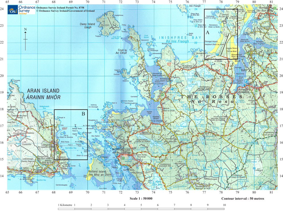
[Source: Ordnance Survey Ireland Permit No. 8758 © Ordnance Survey Ireland/Government of Ireland]
Using map evidence, describe the effects of deposition in Area A.
Using map evidence, explain one likely conflict between types of human activity in:
(i) Area A,
(ii) Area B.
Examine the sources and impacts of waste disposal in oceans.
Markscheme
The most obvious signs of deposition in Area A are the two beaches [1 mark], one on either side of the airport. Each beach is about 1.5 km long [1 mark] and about 0.25–0.5 km wide [1 mark]. The beach to the east is wider than the beach to the west [1 mark]. It is possible that the entire neck of the peninsula (where the airport is built) is the depositional feature known as a tombolo [1 mark], joining a former island to the mainland. There are also small areas of deposition in square 77/23.
Award 1 mark for using the term “beach” and an additional 1 mark for each additional point made about them, or for further development of an idea.
Accept any other valid suggestion about deposition in Area A, provided that there is some map evidence to support it.
Most conflicts are likely to concern competition for land use.
(i) Area A
- Airport/local residents
- Airport/agriculture.
(ii) Area B
- Ferry traffic/fishing/recreational boaters (ferry vehicle route shown)
- Tourism/local interests/land uses
- Lifeboat station/prevention of other developments in the area.
Award up to 3 marks for each conflict that uses map evidence (names or grid references), is well explained and shows how two land uses are incompatible.
Sources may include:
- Agriculture in the form of pesticides and fertilizers
- Industrial waste, especially heavy metals (for example, Minimata mercury poisoning in Japan)
- Raw sewage from urban/residential developments
- Radioactive waste from power stations or the impacts of warm water as a by-product
- Disposal of oil waste from tankers
- Ship wastes including plastics.
Impacts may include:
- Eutrophication and algal blooms from fertilizers
- Bleaching of reefs from increased temperatures
- Damage to marine life from heavy metals or radioactive waste
- Changes to water clarity and turbidity from shipping and industry
- The impacts of oil waste on marine life and the littoral zone may also be
- considered.
To access bands E and F, answers should examine at least two sources and impacts, though do not always expect a balance.
Marks should be allocated according to the markbands.
Examiners report
Responses to this question were very weak at both levels, with most gaining more marks for part (b) than for part (a).
Most gained more marks for part (b) than for part (a).
Examples used were not always valid. For instance, the Trafigura event did not involve "waste disposal in oceans", nor could an accidental oil spill from a rig explosion really be considered as "waste disposal", so that a number of responses simply examined ocean pollution from any source.
The map shows the Cape Hatteras area of the east coast of the USA. The satellite image shows Hurricane Irene (2011), a few days before it reached Cape Hatteras.
Using map evidence, describe two depositional landforms found on this coastline.
Explain how one geopolitical conflict has developed in relation to a named oceanic resource.
“The fishing industry can never be sustainable.” Discuss this statement.
Markscheme
Award [1 mark] for identifying each landform and [1 mark] for development/description provided map evidence is used (may use: names, scale, grid reference, compass bearing, etc). For example, award [2 marks] for “the map shows a spit approximately 8 km long”.
The map includes:
- spit (barrier island/bar)
- beach
- dunes
- marsh
- mudflats.
Likely resources could include oil, gas and/or fish. However, other resources are equally valid, for example, manganese, gold, diamonds, gravel. Award [1 mark] for the resource that is shown to be a cause for conflict.
For example, for oil, some may use the Falklands/Las Malvinas, Rockall or North Sea as their chosen conflict/conflict area, or Australia/East Timor. In each case, the countries involved in any dispute should be identified [1 mark] for the resource that is shown to be a cause for conflict. The remaining [4 marks] should be awarded for the explanation of how and/or why the conflict developed, or was subsequently managed/developed.
Overfishing occurs widely within the industry. Overfishing occurs when catches exceed the maximum sustainable yield for any year or other period of time. It occurs because fishing technology has become too mechanized/large-scale, such as with the use of factory ships and on-board technology such as sonar (used routinely to locate fish). The growing demand for fish as incomes rise in emerging economies means pressures are only increasing for higher yields.
However, remedies designed to conserve fish stocks and make fishing more sustainable include:
- increasing mesh size and discouraging the catch/marketing of juvenile fish
- reducing the fishing yields by restricting time spent at sea, or length of fishing season, or the size and number of boats
- imposing fishing permits, quotas (for example, EU’s Common Fisheries Policy) and import tariffs
- satellite and logbook surveillance and penalties for illegal landings.
Candidates are not expected to include all of these, the relevance of which depends on the example chosen.
At band D, responses are likely to be descriptive of the problems of sustainable fishing.
At bands E/F candidates need to consider how fishing can become more sustainable, and at band F there should be a clear conclusion.
Marks should be allocated according to the markbands.
Examiners report
Outline the global distribution of oceans.
Explain two ways in which wind action helps different coastal landforms to develop.
“Geopolitical conflicts over oceans, including their resources, will only get worse in the future.” Discuss this statement.
Markscheme
Award [1] for each valid point.
Possibilities include:
- oceans cover about 70% of the Earth’s surface [1]
- however, their distribution is uneven. There is more ocean in the southern hemisphere than the northern hemisphere [1]; valid quantification, eg up to 90% of the southern hemisphere is ocean [1]
- there are seasonal variations in the amount of open water, especially in the Northern Hemisphere (Arctic) [1]
- names at least three oceans in context with distribution [1].
Credit other valid distributional comments.
If only a list of oceans is provided, award no more than [1].
Award [1] for each wind action that is described, eg prevailing winds, and a further [1] for explaining how this helps an identified landform [1] to develop.
Wind action could be discussed in terms of: strength (strong onshore winds); direction; destructive/constructive waves; length and direction of fetch.
Possible coastal landforms include: shingle beaches and ridges (berm), sand beaches, sand dunes, cusps, cuspate foreland, barrier beaches, caves, stumps, wave-cut notch, wave-cut platform. The role of wind must be made clear for full marks if a landform approach is taken (see third example below).
For example:
- wind action transports sand onshore [1] and explains how this gets trapped by vegetation, eg marram grass [1] to form sand dunes [1]
- prevailing winds influence longshore drift (along with ocean currents) [1] and explains the movements of swash and backwash [1] that helps form spits, bars or tombolos [1]
- wind action influences wave energy [1] and therefore erosion such as hydraulic action or abrasion [1] and this helps form erosional features such as cliffs and stacks [1].
Conflicts over resources are likely to increase – partly due to population growth and partly due to economic growth/rising living standards. This is driving up demand for resources such as oil, gas and fish. As land-based resources decline, pressure to develop ocean-based resources will increase. Examples are likely to include oil and gas in the Arctic, ocean fisheries (a “common resource”).
However, it may be possible to manage resources eg Common Fisheries Policy, Marine Stewardship Council, etc. The severity of future resource shortages is also unknown and is contingent on many factors.
Good answers may show greater understanding of the term “geopolitical conflicts” and may discuss the extent which tension or actual conflict is the result. Another approach might be to examine the geographical scale of the different players who are in conflict: these might range from nation states to individuals (eg piracy).
For band D, expect some description of one or more conflicts clearly linked to oceans and/or their resources.
At band E expect either more detailed explanation of one or more conflicts or some structured discussion of the degree to which they are likely to worsen, or be resolved, in the future.
At band F expect both of these elements.
Marks should be allocated according to the markbands.
Examiners report
Many candidates experienced some difficulty in describing the global distribution of oceans, although this is in the syllabus. Nearly all were able to name three oceans and the majority commented on how much of the planet was covered in water. However few made comments on distribution between hemispheres and hardly any discussed seasonal variations. Many tried to link distribution to ocean currents and the conveyor belt system. There were some good location maps drawn showing the oceans relative to the named continents but this was only worth 1 mark.
Stronger candidates were able to discuss the formation of different coastal landforms, although not all were able to fully explain the influence of wind. This was particularly the case when making the connection between wind, wave strength and erosional processes. Candidates were much stronger on longshore drift and associated landforms, and the development of sand dunes. There were some good, labeled diagrams of the formation of a spit but also some very poor ones, without labels or arrows in the correct direction.
Candidates were generally strong on the reasons for conflicts over oceanic resources but use of case study examples was sometimes weak. Most were able to refer to an oceanic resource other than fishing, such as oil and discussed the issues regarding sovereignty rights and EEZs. Most candidates focused on the Arctic Ocean and South China Sea as examples but details were often lacking and in some cases inaccurate.
The diagram shows wind frequency over a 30-year period on a beach in the Caribbean.

[Source: © International Baccalaureate Organization 2018]
Estimate the percentage of days when the wind blows from the north.
Identify the direction of the most frequent wind.
State the direction towards which longshore drift is most likely to occur at X on the diagram.
State one landform likely to be produced by longshore drift at X.
Explain three physical factors that affect the development of coral reefs.
“Coastal hazard management always creates more problems than it solves.” Discuss this statement, with reference to one or more areas of coastline.
Markscheme
15 % (accept 13–17 %).
ESE (accept SE).
West/north west/west northwest.
Spit.
Award [1] for each factor explaining the development (growth or decline) of coral and [1] for its development and/or exemplification.
For example:
- Presence of polyps/zooxanthellae (soft animals) [1] which produce calcium carbonate to form the reefs [1].
- Sunlight for photosynthesis [1]; coral growth favoured in tropical oceans where sunlight is more intense [1].
Other factors include:
- clear, shallow water
- optimal sea temperatures of 23–29°C
- acidity of water
- salinity of water
- where water is less saline
- natural hazards can destroy reef
- natural predators
- climate change.
The question can be answered using any coastal hazard, including tsunamis, storm surges, coastal erosion and cliff failure. Answers should include a discussion of the conflicts involved with coastal hazard management. These may include access, decline of amenity value, cost, disruption of ecosystems, impact on fisheries, impact on transport or lack of management.
For example, sea walls may be built to reduce the threat of tsunamis and storm surges but may interfere with natural ecosystems and shipping routes. Erosion may be managed using hard and soft engineering, but this may affect the aesthetics of an area and reduce its recreational/tourist impact. A “do nothing”/managed retreat may anger local residents land owners.
In contrast, many people feel more secure as a result of attempts to manage coastal hazards, and do not see a conflict of interest.
Good candidates may discuss different coastal hazards and stakeholders and cover both sides of the argument. Another approach may be to examine the scale of the hazard, eg a 50-year event may be planned for, but the scheme will not protect against an event of higher magnitude. Others may consider the possible impacts of climate change.
At band D, expect a description of the hazard management of one or more areas of coastline.
At band E, expect either a detailed explanation of the hazard management of one or more areas of coastline or a discussion of the problems created and resolved by hazard management.
At band F, expect both.
Marks should be allocated according to the Paper 2 HL and SL markbands.
Examiners report
The graph shows changes in average annual ocean salinity and temperature with depth.

Referring to the graph:
(i) describe how ocean salinity varies with depth;
(ii) describe how ocean temperature varies with depth.
Explain three economic benefits of mangrove swamps.
To what extent have the management strategies adopted to resolve human pressures on one named coastline been successful?
Markscheme
(i)
Award up to [2] for any two points, provided at least one point has been quantified.
- Ocean salinity is lower nearer the surface (around 32.5 ppt) [1].
- Salinity increases very slowly in the top 100 m of ocean [1].
- Between 100 m and around 750 m ocean salinity increases quite rapidly (from 32.5 ppt to over 34 ppt) [1].
- From 750 m to about 1500 m ocean salinity increases slowly (from over 34 ppt to less than 35 ppt) [1].
(ii)
Award up to [2] for any two points, provided at least one point has been quantified.
- Temperature is highest nearer the surface (13–15°C) [1].
- Temperature is fairly constant in the top layer of water (to about 100 m) [1].
- Temperature decreases rapidly from about 100 m to 250 m (from about 13–15°C down to about 5°C) [1].
- Below 250 m temperature decreases slowly [1].
Award [1] for each economic benefit and a further [1] for development/exemplification.
Mangrove swamps provide many economic benefits, including:
- food, especially fish such as shrimp – these form the basis of a fishing industry
- fuel – the wood can be burnt for fuel
- building material – the wood can be used for fencing/housing
- protection against hurricanes/tsunamis – reduces losses/reconstruction costs
- high levels of biodiversity – unique wetland environment so ecotourism
- some species are used for medicines – eg for skin disorders, sores and for throat cancer; this has indirect economic benefits
- reduced costs for environmental clean-up agencies by absorbing nutrients from farming and sewage disposal.
For example:
Mangrove swamps support a fishing industry [1] because they provide a breeding ground for fish [1].
There are many different pressures in coastal areas: tourism and recreation; fishing; transport; energy developments; conservation; settlement; trade; industrial development; water abstraction; sand mining etc. These pressures tend to lead to conflicts over management strategies.
Conflict may be small-scale eg between dog walkers and families on Studland Beach, or between fisher folk and conservationists in Soufriere, St Lucia. It may also be large-scale, eg the proposed coal mining and transport of coal via the Great Barrier Reef, Australia.
Coastal management strategies include land-use zoning; coastal protection schemes; managed retreat; conservation areas; coastal reclamation; hard and soft engineering schemes; user fees; seasonal; establishment of management bodies; preparation of information materials (such as notice boards); inclusion of all stakeholders.
Good candidates may recognize that it is not possible to resolve conflicts/please all stakeholders but a good strategy may involve compromise that different parties can live with, eg aesthetically pleasing defences. Also, conflicts may become more common and therefore harder to resolve as tourism grows, technology develops and land-based activities put more pressure on the coastal
zone. There may be conflicts within stakeholder groups, eg some fishermen are mainly subsistence whereas others are commercially orientated.
An alternative approach might be to compare management strategies on two coastlines in order to assess their relative success.
At band D expect a description of coastal management strategies for a named coastline.
At band E expect either an explanation of coastal management strategies or an attempt to evaluate the relative success of named coastal management schemes in resolving conflicting pressures.
At band F expect both.
Marks should be allocated according to the markbands.
Examiners report
Many candidates struggled with reading the graph. Many could not get beyond simple description regarding increase/decrease and rarely used sufficient quantification.
This was generally well answered, showing good understanding of the benefits of mangrove swamps; although sometimes not well developed.
Although there were some strong responses, this question often caused significant problems. The question focused on resolving conflicting human pressures on a coastline. However, a limited range of management strategies was recognized. Most candidates simply described a selection of hard and soft engineering strategies, with little focus on human pressures, and little evaluation of their effectiveness.
The graph shows the global production of fish from coastal aquaculture and ocean fishing between 1980 and 2015.

(i) Describe what is meant by the term “aquaculture”.
(ii) Describe the trends in coastal aquaculture shown on the graph.
(i) Briefly outline the sovereignty rights of nations in relation to oceanic resources.
(ii) Explain how oceanic resources are the cause of one geopolitical conflict.
Compare the importance of coastal processes and lithology for the formation of two or more coastal features.
Markscheme
(i)
Raising aquatic organisms commercially/fish farming [1]. This is common in coastal margins / gives a locational example [1]. Other valid points may be credited.
(ii)
Award up to [2] for any two points made, provided at least one point has been quantified.
For example:
Aquaculture begins at a very low level and has increased dramatically since the 1980s [1].
Over the period aquaculture has grown from about 5 million tonnes to 70 (allow 68–70) million tonnes [1].
(i)
Award [1] for a statement about sovereignty rights, and a further [1] for further development/exemplification (eg resource and nation).
For example:
Coastal countries may claim exclusive/sole rights over oceanic resources in their own coastal waters [1].
Oil fields off the coast of Nigeria [1].
(ii)
Award [1] for the identification of the countries involved in the conflict and the nature of the conflict.
Award [1] for extended description of where/when the conflict arose, for example Japan and Korea’s claims over the Sea of Japan / East Sea date back to the Second World War.
Award a further [2] for the explanation of why this resource is the cause of conflict.
The explanation may focus on the changing value of the resource, changes in accessibility, eg thinning of Arctic ice, multiple claims on the same area by neighbours, provides greater detail of why an area of sea floor does not fall into the EEZ of only one particular country.
For example: There is ongoing conflict between the UK and Argentina over the UK’s claim to the sea around the Falkland Islands (Las Malvinas) [1]. There was war at one point in the 1980s [1]. The sovereignty dispute is partly related to substantial reserves of oil in the region [1]. This oil could be worth more as global demand rises so the conflict may continue [1].
Coastal processes include wave action (erosion, transport and deposition), wind action, littoral drift, and subaerial processes (weathering, eg salt crystal growth, and mass movement, eg slumping).
Coastal features include erosional landforms such as cliffs and wave-cut platforms, as well as depositional landforms such as spits and bars.
Lithology, in its broadest sense, refers to rock properties eg strength, hardness, permeability (jointing) and chemical composition. Rocks can generally be divided into relatively strong and relatively weak rocks. Lithology may be relatively unimportant for some depositional features (eg sand dunes and salt marshes) whereas it is very important for the development of cliffs and marine (wave-cut) platforms.
Good candidates will recognize that most coastal landforms are the result of the interplay of coastal process and lithology. For example, a high energy coast acting on a strong, jointed rock may produce caves, arches, stacks and stumps.
At band D, expect some description of two features/landforms, and some reasons for their formation.
At band E, expect either greater explanation of how coastal processes and lithology (do not expect balance) give rise to coastal landforms/features or some explicit comparison of their importance.
At band F expect both.
Marks should be allocated according to the markbands.
Examiners report
(i) Although the term aquaculture was often understood, few developed the point further.
(ii) There was inability to read the graph correctly and inaccurate quantification was often given. Many quantified using total, rather than aquaculture, figures.
(i) Few problems.
(ii) Most were able to explain one relevant geopolitical conflict.
This was often poorly answered, showing limited understanding of coastal processes and lithology and their relation to landforms. Answers were often descriptive and omitted reference to lithology. The comparison of relative importance was often weak.
Identify two abiotic resources found in each of the following:
(i) continental shelf areas
(ii) ocean floor deposits.
Explain three consequences of oil pollution in oceans.
Examine the effects of the loss of coral reefs and mangrove swamps.
Markscheme
(i) Award 1 mark for each valid resource identified, for example, placer deposits, oil and natural gas.
(ii) Award 1 mark for each valid resource identified, for example, manganese nodules, zinc, phosphates, sulphates, copper, lead, silver.
Possible consequences include:
- reduction in biodiversity
- declining ecological and/or economic productivity
- costs of clean-up operations
- social costs such as loss of livelihoods (short- and long-term unemployment)
- political costs such as after Deepwater Horizon.
Credit other valid consequences.
Award 1 mark for the description or example of each consequence and 1 mark for each explanation.
It is likely that most answers will refer to the possible causes of loss of coral reefs and mangroves as a first step to examining the effects of such loss.
The consequences of the loss of coral reefs are:
- erosion of coastlines
- loss of fish habitats (occupying less than 0.25% of the marine environment, they nevertheless shelter more than 25% of all known fish species)
- loss of biological and economic productivity
- loss of biodiversity
- loss of breeding and feeding grounds for fish
- economic and social loss to people who depend on fishing and/or coral reef tourism/diving.
Some of these effects are similar in the case of mangrove swamps.
In addition, a loss of mangroves may reduce the amount of available food and fuel, building materials and medicine. Mangroves also act as natural filters, absorbing nutrients from farming and sewage disposal.
Both coral reefs and mangroves protect coastlines by absorbing some wave energy, especially during storms such as hurricanes (tropical cyclones). The dense interlocking roads of mangroves help to stabilize shorelines and prevent erosion.
The loss of coral reefs and mangroves is not entirely negative. Removing them may improve navigation. Material eroded from coral reefs can accumulate to form attractive (and economically important) white-sand beaches. The destruction of mangrove swamps may allow for the construction of hotels, harbours and marinas.
Answers accessing markbands E/F should include the consequences of both coral and mangrove loss. Examples would be expected for bands E and F.
Marks should be allocated according to the markbands.
Examiners report
Few candidates had difficulty with this question.
Few candidates had difficulty with this question although it was not always easy for examiners to decide exactly where one consequence ended and the next began.
Responses tended to spend far too long describing causes (not required by the question) and too little time on effects and their consequences. Relatively few responses acknowledged any possible positive effects.
Option B — Oceans and their coastal margins
The map shows the distribution of coastal “dead zones” in North America and the Caribbean. A dead zone is an area with significantly reduced marine life (due to pollution).

(i) Describe the location of dead zones.
(ii) Outline how chemical waste may result in a dead zone.
Briefly explain the formation of:
(i) one coastal landform resulting mainly from erosion;
(ii) one coastal landform resulting mainly from deposition.
“Management strategies for coastlines are generally ineffective.” Discuss this statement with reference to one named coastline you have studied.
Markscheme
(i) Possible statements may include:
- more dead zones in the Gulf of Mexico / along the coast at 30° N / around Caribbean
- they are mainly located on the east coast (of the USA)
- there are none at high latitudes
- there are only two on the west coast.
Award [1 mark] for each valid statement.
(ii) Award [1 mark] for establishing a link with mortality/reproduction impairment for marine life and [1 mark] for a suggestion of how this leads to a dead zone/larger scale of mortality. For example:
“Chemicals entering the water are toxic to fish [1 mark] with wider impacts due to food chain transmission [1 mark].”
(i) Erosional features are likely to include cliffs, arches, stacks.
Award [1 mark] for a clearly identified coastal landform linked to a process and a further [1 mark] for each valid explanatory statement.
For example: “A cliff [1 mark] formed when hydraulic action creates a wavecut notch [1 mark] which leads to the collapse of the rock above [1 mark].”
(ii) Depositional features may be linked to constructive waves and wind. Likely features could include beaches and bars, spits, tombolos, sand dunes, salt marsh, etc.
Award [1 mark] for a clearly identified coastal landform linked to a process and a further [1 mark] for each valid explanatory statement.
For example: “A spit [1 mark] is formed by longshore drift moving beach material sideways [1 mark] when the wind drives the waves at an oblique angle to the shoreline [1 mark].”
Credit all content in line with the markbands. Credit unexpected approaches wherever relevant.
An area of coastline should be named and located. If more than one coastline is referred to, credit only the first.
In order to judge how effective actions have been, the (conflicting) pressures on the coastline should be identified in order to establish why management was needed. Possible content might include: hard and soft coastal defences, ecosystem restoration, managed retreat, ecotourism, etc.
Better responses may discuss what is meant by “ineffective” (eg compares different user groups along the same coastline, or takes short and long term view or another cost-benefit approach).
Answers that do not refer to a specific stretch of coastline should not proceed further than band C.
At band D, responses should describe some strategies for a named coastline, and may assert they were effective/ineffective.
For band E, there should be either greater detail of the strengths and weaknesses of a range of (at least two) strategies, or a narrower but more sophisticated discussion of the veracity of statement (eg good account of how a strategy can be effective for some users, but damaging for others).
At band F, expect both elements.
Examiners report
(i) Correct locations were described.
(ii) Dead zones could be attributed to toxicity/mortality but few were able to link this to the wider implication of affecting the food chain.
Both parts to this were generally done well, with some excellent supporting diagrams, referring to an example. A concerning number of candidates were unable to identify and explain either an erosional or a depositional coastal landform; consideration of processes was often weak.
A straightforward question that was reasonably well answered. Most were able to describe management strategies and comment on their effectiveness. Again, the best responses included an annotated sketch map, and there were some good examples from the Australian coastline.
The diagram shows four landforms (A, B, C, D) associated with a cliff.

(i) Identify two of the landforms shown in the diagram.
(ii) Outline how wave action could lead to the collapse of the cliff.
Explain three factors favouring the growth of coral reefs.
Examine the environmental and economic impacts of the pollution of oceans by oil.
Markscheme
(i) Any two of the following for [1]:
A cave
B stack
C arch
D wave-cut platform or shore-cut platform
[1 mark]
(ii) Award [1] for each valid point.
Possibilities include:
- eroded by hydraulic action/force of the wave
- abrasion/marine processes
- chemical processes, eg carbonation
- a notch is formed between low water mark and high water mark
- the notch is enlarged, the cliff becomes unstable and collapses.
Maximum [2] for an outline of processes that does not address the final point about notch and collapse.
[3 marks]
Award [1] for each reason and a further [1] for development/exemplification.
Possibilities include:
- sunlight is important for photosynthesis [1] – coral reefs contain algae (zooanthellae) which photsynthesize [1]
- salinity – coral not favoured by low salinity/freshwater [1] and is mainly in areas where the salinity is between 32 and 40 PSU (practical salinity units) – sudden decreases in salinity in oceans off major rivers may destroy coral [1]
- depth – coral is limited to about 100m [1] as below that it is too dark to photosynthesize effecitively [1]
- temperature – coral reefs grow most between 18–30°C [1] – most reef building coral cannot tolerate temperatures below 18°C and can only survive high temperatures for short periods [1]
- acidity of seawater [1] – increased acidity leads to less growth/decreases capacity of coral to build skeletons [1]
- pollution of oceans [1] – decreases water quality/less coral growth [1]
- management strategies [1], to protect reef/research/encourage growth [1].
[6 marks]
Environmental impacts might include: degraded ecosystems, flora and fauna mortality, reduced ecosystem productivity. The impacts may be concentrated in particular areas eg shipping lanes, offshore oil fields and nearby coasts.
Economic impacts might include: cost of clean-up, reduced fishery catches, unemployment, reduced tourism/recreational value, higher cost of oil (linked with possible restrictions on oil production or fines for companies, eg costs incurred by BP in relation to Gulf of Mexico).
Good answers may be carefully structured around an examination of different kinds of environmental and economic impacts. These may be local or global, short-term or long-term, small-scale or large-scale, intentional or unintentional. Impacts may also be experienced at a different place from the source of pollution due to tidal movements, and this may be examined. Good answers may also examine how impacts and cost may be spread across different user groups/stakeholders.
At band D, expect a description of some environmental and economic impacts of oil pollution.
At band E, expect either a more detailed and balanced explanation of the economic and environmental impacts of oil pollution or a structured attempt to examine some different aspects of the impacts (eg severity or spatial extent).
At band F, expect both.
Marks should be allocated according to the markbands.
[10 marks]
Examiners report

Describe the pattern of ocean salinity shown on the map.
Explain what is meant by the La Niña phenomenon.
Using examples, analyse two economic impacts associated with La Niña.
Examine the role of oceans as a store and source of carbon dioxide.
Markscheme
Highest salinity levels are found towards the tropics [1 mark] with higher levels in the Atlantic than the Pacific [1 mark]. Salinity levels generally decrease towards polar areas [1 mark]. Award [1 mark] for accurate quantification.
La Niña refers to an intensification of “normal” ocean temperature conditions [1 mark], bringing colder temperatures in the eastern Pacific and warmer in the west [1 mark]. Alternatively, there is high pressure in the eastern Pacific, low pressure in the western Pacific [1 mark], a high altitude flow from west to east, and a surface flow from east to west [1 mark].
- Loss of crops due to droughts and floods
- Cost of re-building damaged infrastructure (Australia, Brisbane floods, 2011)
- Costs of securing safe water supplies
- Benefits of increased fish stocks (Peru).
Award [1 mark] for an outlined impact and [1 mark] for use of examples.
The oceans account for an important share of the world’s carbon dioxide (fossil fuels 10 000 × 1012 kg, atmosphere 750 × 1012 kg, and oceans 38 000 × 1012 kg). They also play an important role in the carbon cycle. Photosynthesis by phytoplankton forms
organic compounds of carbon dioxide. Some of this passes through the food chain and sinks to the ocean floor where it accumulates in sediment. Eventually it is destroyed at subduction zones and later released during volcanic activity. It is a very long time-scale. Oceans also absorb and then store in solution carbon dioxide derived from the air.
Candidates may look at spatial variations in oceans as a source (more in warmer, nutrient rich water) and stores.
To access band D candidates must explain both store and source (balance not necessary). At bands E and F, a structured examination of both store and source begins to address the role/importance of the oceans.
Marks should be allocated according to the markbands.
Examiners report
Many found it difficult to describe the pattern of ocean salinity, although the best answers made effective use of quantitative information shown on the map.
There were some very good, detailed responses to this question. Unfortunately, a minority confused La Niña with El Niño and the impacts were assigned to the wrong locations.
There were some very good, detailed responses to this question. Unfortunately, a minority confused La Niña with El Niño and the impacts were assigned to the wrong locations.
Some good answers on oceans and carbon dioxide, and the better answers were well-structured. However, in general, this topic was not well understood.

Describe the size and location of the oceanic “garbage patch” shown.
Explain why most types of ocean pollution occur along coastal margins.
Compare the conflicts that arise in coastal areas from habitat restoration schemes with those that arise from aquaculture.
Markscheme
The garbage patch is approximately 5000 to 6000 km long (west to east) [1 mark] and 500 to 600 km wide (north to south) [1 mark].
Likely responses include the middle of the Pacific Ocean [1 mark], towards the sub-tropics/tropics [1 mark], inside a major ocean current cell/gyre/loop [1 mark] (such as the North Pacific current, the North Equatorial Current and the Kuroshio current), latitude 30°N, longitude 140°W to 160°E [1 mark].
Award [1 mark] for each valid point and a further [1 mark] for additional detail.
Most oceanic pollution occurs relatively close to its source. Award [2 marks] for indentifying different types of oceanic pollution (solids, solutes, radioactive materials, oil and chemical wastes). Likely coastal sources of pollution include landbased sewer systems, river systems, ports, a range of local industry including nuclear [2 marks]. Award the remaining [2 marks] for explanation of oil tankers, sea-trading vessels and fishing vessels producing pollution that is moved onshore by ocean currents and/or wind systems; or noting that ocean currents can move pollution towards coastal margins of sparsely populated areas eg Alaskan wilderness.
Conflicts associated with managing habitat restoration include conflicts between local residents, industrialists, environmentalists. Attempts to manage restoration could include introducing clean-up programmes, limits to visitor access and species reintroduction, etc. The source of the conflicts may include costs, funding, employment, local involvement, etc.
For aquaculture, conflicts might develop as a result of the introduction of exotic species, the transmission of disease, the release of chemicals into the water. There may be conflict between the aquaculture industry and local fishermen, environmentalists, water safety personnel, for example.
To access band D, both sets of conflicts must be described (balance is not necessary). At bands E and F, there should be some explicit comparison (eg severity, similar or different causes, or stakeholders).
Marks should be allocated according to the markbands.
Examiners report
This question proved challenging, with many unable to describe both size and location effectively.
Quite a good knowledge and understanding of types and sources of coastal pollution.
This question was generally poorly answered. Many candidates do not understand the meaning of the term “aquaculture”, choosing to write about overfishing, and there were few examples of habitat restoration. They also found it difficult to compare the conflicts. Some misinterpreted the question assuming there was a choice between aquaculture or habitat restoration in a region.
Optional Theme B — Oceans and their coastal margins
4. The photographs A and B show two coastal areas.
Photograph A

Photograph B

(i) State which of these photographs shows an advancing coast.
(ii) Identify one landform in the photograph you have chosen that shows it is an advancing coast.
(iii) Define the term advancing coast.
Distinguish between the climatic conditions experienced on the east coast and the west coast of the Pacific Ocean during an El Niño event.
Using examples, examine the geographic consequences of the pollution of oceans.
Markscheme
(i) Photograph B
(ii) Raised beach or abandoned/relict cliff
(iii) Advancing coasts are coasts that are growing [1 mark] as a consequence of deposition/sediment deposit and/or the infill of coastal marshes [1 mark] or due to a sea level fall (or uplift of land) [1 mark].
During El Niño events there is low pressure [1 mark] off the west coast of South America, rising air, and therefore rain (and floods) [1 mark].
Whereas off the east coast of Australia there is high pressure [1 mark], descending air and drought [1 mark].
Award the remaining [2 marks] for further development, eg, upper level winds blow westwards, surface level winds blow eastwards, or the use of a diagram/diagrams.
Award up to [2 marks] for an answer that correctly links pressure and weather but confuses east and west.
The consequences are varied and could include environmental (eg, oil spills affecting coastal ecosystems), social (shrimp fishermen affected by death of shrimps and their food supply), economic (falling revenues) and political (who pays, cleans up, etc). Implications could be divided into short-term and long-term implications for people (health, employment, potential for tourism, etc). There may be other valid approaches.
Good answers may do more than list consequences for a single place; they may show how geographic consequences are interrelated (eg pollution in one local area has consequences for other global areas also, due to oceanic circulation; oil pollution in Gulf of Mexico brought a temporary halt to deep oil exploration in other countries; transmission of toxic chemicals through marine food chains/webs may result in worst consequences being experienced at a distance to the actual pollution point source).
For band D, responses should describe at least two consequences related to pollution.
At band E expect either a greater range of consequences or some examination of how consequences for different places/scales are interrelated. At band F, expect both.
Marks should be allocated according to the markbands.
Examiners report
Most candidates correctly identified photograph B. The term advancing coast was not understood by many candidates, and hence parts (ii) and (iii) were poorly answered. Most candidates did not recognize the raised beach or abandoned cliff line on the photograph.
There were some very good answers but many candidates confused east and west. Many wrote a lot about the change in ocean currents/temperature/fishing industry, but not about the climatic conditions. A simple, annotated diagram to show the operation and impact of El Niño would gain credit.
There were some very good answers, with appropriate case studies relating to the consequences of ocean pollution. The weakest answers were largely descriptive, and not focusing on consequences of pollution.
The photograph shows part of an advancing coast.

Describe two physical and/or human features shown in the photograph that suggest this is an advancing coastline.
Explain how oceanic trenches are formed.
“There are no simple solutions for the conflicts that arise over the use of coastal areas.” Discuss this statement.
Markscheme
In each case, award [1] for a brief statement of evidence (either a landform feature or reference to human activity), and [1] either for an extended description of the feature, or an explicit link that is made with the fact that the coast is advancing.
For example:
- the land here is very flat/sandy [1] suggesting it may be new land, a result of deposition by constructive waves [1]
- there is a new industrial/port area extending out from the coast [1], which is sited on land that appears to have been recently reclaimed from the sea [1]
- the main landform appears to be a spit [1]. There are a number of recurves (eg in square D3) located along the spit as a result of deposition over time [1]
- the growing marsh/salt marsh [1] is the result of freshwater from the stream mixing with salt water in an enclosed environment [1].
Award up to [2] for description and location of ocean trenches, and [4] for an explanation of their occurrence.
Description:
- very long, linear (underwater) features [1]
- the deepest parts of the oceans [1]
- may offer example(s) [1].
Explanation:
- formed at oceanic-continental subduction zones [1]
- denser oceanic crust plunges under less dense continental crust [1]
- alternatively, at an island arc system, denser ocean crust plunges under less dense ocean crust [1]
- as the plunging plate subducts into the mantle, it forms a steep, deep trench, typically at an angle of 45° [1]
- the cause of plate movement is convection currents in the mantle, causing material to be pushed away from mid ocean ridges [1]
- provides relevant diagram [1].
Credit other valid points.
There are many competing land uses in coastal areas – urbanization, transport, tourism, recreation, fishing, industry, energy production, conservation. This can lead to many conflicts eg access to the land, use of resources, conflicts between farmers, developers, local residents etc.
Conflict can also arise over the use of coastal waters eg aquaculture, mangrove management, wind farms, etc.
For example, urbanization may lead to the loss of habitat/species diversity/lowering of groundwater, causing salt water intrusion/water pollution. This may anger those who are trying to conserve natural habitats and biodiversity.
Full marks can be achieved by a discussion of two conflicts and their possible solutions (do not expect balance).
Good answers may highlight the uneven power of different user groups (meaning that conflict is brushed aside rather than resolved). Another approach might be to establish interrelationships with processes such as in-migration, economic development or long-term sea-level changes: any of these processes may mean that conflicts over land use are especially hard to resolve.
If the candidate refers to geopolitical conflicts in relation to oceanic resources, rather than conflicts on a coastline, do not award above a band C.
At band D, expect an identification/description of at least one conflict (and interest groups) or description of some general solutions/strategies for coastal management.
At band E, expect either more detailed explanation of two conflicts and possible solutions, or some critical discussion of why conflicts are difficult to resolve.
At band F, expect both.
Marks should be allocated according to the markbands.
Examiners report
The photograph shows an area of sand dune restoration.

(i) State one natural cause and one human cause of sand dune degradation.
(ii) Identify two ways in which people are attempting to restore the sand dunes shown in the photograph.
Briefly explain the characteristics and formation of two ocean floor landforms found at a constructive plate boundary.
Examine the possible impacts of changes in the ocean carbon store.
Markscheme
(i) Natural cause – strong winds / blow outs / storms [1]
Human cause – trampling/foot path erosion / fire/barbeques / introduction of exotic species (eg rabbits) / dune boarding [1].
[3 marks]
(ii) Award [1] for each valid statement.
Possibilities include:
- fencing off/closing off areas to prevent further erosion of the dunes/destruction of the vegetation
- signage to keep people out
- replanting of sand dune species, eg sea couch and marram grass.
[3 marks]
For each landform explained, award up to [2] for a description of the landform’s characteristics and up to [2] for an explanation of its formation, up to a maximum of [3].
For example: A mid-ocean ridge is a submarine linear mountain range [1] formed by two plates moving apart due to convection currents [1] and magma rising to produce a volcanic ridge [1].
Other possibilities include:
- rift valleys at constructive plate boundaries
- seamounts (guyots) are formed at constructive boundaries but have since moved away
- transform faults
- shield volcanoes
- pillow lava
- black smokers.
[6 marks]
Oceans play a key role in the carbon cycle. The major reservoirs of carbon dioxide are fossil fuels (10 000 × 1012 kilograms of carbon), the atmosphere (750 × 1012 kilograms of carbon) and the oceans (38000 × 1012 kilograms of carbon). Photosynthesis by plankton generates organic compounds of carbon dioxide. Some of this material passes through the food chain and sinks to the ocean floor, where it is decomposed into sediments.
Oceanic uptake of CO2 has halved since the 1990s. This may be due to the oceans being saturated with respect to CO2. As the oceans absorb more carbon, they become more acidic. The implications of this are that climate change may accelerate if the oceans can no longer absorb carbon; coral reefs may die back due to acidification; species such as crabs and lobsters may decline due to the decrease in calcium building.
Good answers may be carefully structured around different kinds of possible impact, eg positive and negative, environmental and economic, short-term and long-term. These will be grounded in an understanding of the role of the oceans as a store of CO2.
At band D, expect a description of the role of the oceans in the carbon cycle.
At band E, expect either a more detailed explanation of the role of the ocean carbon store or an examination of possible impacts of changes.
At band F, expect both.
[10 marks]
Examiners report
The photograph shows an actively eroding cliff.

State two subaerial processes that may affect the cliff in the photograph and briefly outline how each process operates.
Explain two conflicts that could arise from attempts to manage cliff failure.
Examine the contribution that conservation can make to protecting oceanic fish stocks.
Markscheme
Accept a wide range of processes, provided they are non-marine processes.
Award [1] for each process and [1] for an outline of how the process operates.
Subaerial processes can include mass movements, surface run-off and various types of weathering.
Possible examples include:
- slumping/mass movement [1] is when a cliff collapses due to overlying rock strata/saturated soil becoming unstable/shear strength exceeds resistance [1]
- salt weathering [1] (allow chemical weathering on the cliffs). Salt crystals expand and cause stress to occur in many rocks, leading to disintegration and flaking [1]
- freeze-thaw [1] when fluctuating temperatures allow water to freeze and shatter cliff face [1]
- biological weathering [1] when tree roots (physical)/organic acids (chemical) disintegrate/decompose cliff [1]
- surface run-off [1] occurs when precipitation falling on the land runs over the cliff face leading to gullying/carries away sediment under gravity [1].
Conflicts may be about governance, cost, impacts on different stakeholders, degree of sustainability, aesthetics etc.
Award [1] for a description of the cliff management technique that shows how it prevents failure, [1] for identification of the nature of the conflict/the groups in conflict, and [1] for the explanation of the conflict.
For example: There may be conflicts between people wishing to use a beach for recreation and those trying to prevent coastal erosion [1] eg the use of tetrapods/rip-rap to absorb wave energy [1] on some beaches has reduced the recreational amenity [1].
Credit any other valid points.
Candidates may agree that conservation policies are needed or else the world’s fisheries become unsustainable. Examples could include the decline of certain fishing grounds such as the Grand Banks of Newfoundland or the North Sea. Particular species may be identified – blue fin tuna, cod, whales etc.
Methods to conserve fish stocks and make fishing more sustainable include:
- reducing the fishing yields by restricting time spent at sea, the size and number of boats
- imposing fishing permits, quotas and import tariffs
- preventing improvements in efficiency, by increasing mesh size and discouraging the marketing of juvenile fish.
Good answers may recognize there are limits to protection due to rising demand, illegal fishing, factory fishing, changes in technology, so protection is not guaranteed. They may also question the scale of protection (some places may be easier than others to manage sustainably; some fish stocks may be more easily conserved). Another approach may be to argue that other methods are needed to make a contribution too, including an increase in aquaculture that could produce enough fish to meet demand.
For band D, expect some description of marine conservation.
At band E, expect either more detailed explanation of marine conservation or a structured examination of different methods (or scales) of conservation.
At band F expect both of these elements.
Examiners report
The focus of the question was subaerial processes, although many referred erroneously to marine processes. Mass movement was rarely mentioned.
Some reasonable attempts were made to identify the cliff management and sources of conflict, but in most cases there was not enough development. Strong candidates identified possible conflicts and different interest groups with several referring to actual examples.
Candidates were able to identify different methods of marine conservation and recognized the reasons for the need and likely trends in the future. However, knowledge of case studies was variable, often lacking specific detail. Alternatives to conservation were often not considered.
Map B
Map B shows the area around the city of Prince Rupert (population: 13 000) on the west coast of Canada. The scale of the map is 1:50 000. The contour interval is 40 metres.


Identify and briefly describe two coastal landforms in area X marked on map B.
Using located examples, suggest two reasons why ocean pollution may impact areas far from the source of pollution.
Evaluate the contribution that subaerial processes and wave action make to the development of coastal landforms.
Markscheme
Landforms present in area X include: a spit, lagoon, bay/cove, wave-cut platform, stacks, foreshore flats/sand in water. For example, wave-cut platform/shore platform [1] has a long shallow gradient/is submerged at high tide [1].
In each case award [1] for the located example (credit source or sink regions; or named examples of ocean currents/regions) and a further [2] for the reason offered. If the same example is used twice, award up to a maximum of [5].
Possible examples:
- oil pollution from the Deepwater Horizon oil spill travelled 80 km to make landfall along the US coastline
- ocean currents driving accumulation of plastics in the Great Pacific Garbage Patch
- radioactive material from nuclear power stations/industrial process/research eg Fukushima, Japan
- other named sources for fertilizers/sewage/detergents/plastics.
Possible reasons:
- discharge/channel flow in rivers takes pollution away from source [1] which can lead to the development of eutrophic/nutrient-rich conditions in named coastal areas [1]
- surface movement of oil/solid wastes/chemical spills is driven by ocean currents and wind systems [1] and may provide further details [1]
- ocean movements caused by tropical cyclones [1] may also disperse pollutants into areas far from their source and may give details [1]
- oil may be ingested by some species [1] which travel long distances perhaps for food/breeding grounds [1]
- pollution builds up (bioaccumulation/biomagnification) [1] in species higher up in the food chain which have travelled further for their food supply [1].
For example: Oil pollution from the Deepwater Horizon oil spill in the Gulf of Mexico travelled over 80 km to make landfall along the US coastline [1]. The oil spill was driven by ocean currents and winds onto the coastline [1]. The oil also covered and was ingested by various marine animals and thus severely affected ecosystems along the Louisiana coast [1].
Credit other valid reasons and developments.
Likely landforms include erosional features, such as cliffs, stacks, arches, wave-cut platforms, and depositional features, such as beaches, spits, bars and dunes. Full marks could be gained through an examination of just two landforms if the balance between subaerial processes and wave action is well evaluated.
- Subaerial processes include weathering, mass movements and surface run-off. Mass movements include slumping, rotational slumps, slides and flows. Weathering processes in coastal areas may be responsible for wave-cut platform, and the weathering of cliffs.
- Wave actions include the actions of destructive (erosional) waves and constructive waves. The former may be involved in the formation of cliffs, arches, stacks, stumps, whereas the latter may be involved in the formation of beaches, spits, bars, barrier beaches etc. Longshore/littoral movements also potentially play a role.
Answers where one set of processes is absent in both cases will be self-limiting as that answer will only explain, and will not evaluate.
Good answers may evaluate explicitly the relative balance of the two sets of processes, perhaps in relation to contrasting landforms. The timescale for process operation could be considered also.
At band D, expect answers which describe two or more landforms in a way that shows how subaerial processes and/or wave action have an influence.
At band E, expect either a wider range of landforms/processes explained or some critical examination of the relative influence/interaction of subaerial and wave processes (for instance in relation to cliffs).
At band F expect both.
Marks should be allocated according to the markbands.